There is a need to calculate the traffic directional distribution inside the Hue Imperial City scientifically and reasonably for preservation and development. Besides, it is needed to do research into the development of a waterway tourism system inside the Imperial City to create a tourist attraction…

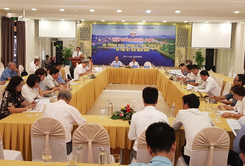
Overall view of the seminar
A great many suggestions were offered at the seminar "Transport system in Thua Thien Hue from the 19th century to the present" organized by the Provincial Association of Historical Science, on June 23.
Mr. Phan Tien Dung, Chairman of the Provincial Association of Historical Science, said that since 1975, especially in the process of renovation, along with the national development, the transport system in the Thua Thien Hue area has undergone positive changes.
The infrastructure system is expanded to meet the needs of local development and serve the people's life.
According to Mr. Dung, in the reigns of Kings Gia Long and Minh Mang (1802 - 1841), the transport system in Hue Imperial City developed strongly. “Transportation is a big field of the country; in Hue capital under the early Nguyen kings, this activity responded to the process of running the country. That was reflected in the strong impact on the fields of politics, economy, culture, military, and diplomacy, forming a powerful Vietnam country in the region, ” explained Mr. Dung.
Conducting in-depth research on the traffic system under the Nguyen Dynasty, with a focus on the waterway system, specifically the canals in Hue, Dr. Thai Quang Trung affirmed that Nguyen lords and kings knew how to exploit their strengths of this land, turning it into the capital of both Đàng Trong (Cochinchina) and the capital of the whole country.
This researcher said that if the canal system in Thua Thien Hue is thought to be just to serve agricultural production, this is unconvinced because this was not a key agricultural area, but it must have been derived from "agricultural benefit" in the context of mainly agricultural production.
“So these canals themselves also serve to separate water for the Perfume River in the flood season, threatening the safety of Hue Imperial City and certainly also play a critical role in transportation," Mr. Trung expressed his view.
Emphasizing the critical role of traffic in Hue before 1885, researcher Nguyen Quang Trung Tien said that as the capital land of Vietnam/Dai Nam in the 19th century, the land for building Hue Citadel was designed by the Nguyen Dynasty to become an island separated from the outside by four sides of rivers. Therefore, the traffic connection between the Hue Imperial City area and the outside world was carefully calculated both to ensure the requirements of defending the capital in the event of an attack and to turn this place into a center connecting and operating favorably with both ends of the country.
According to the research by Mr. Tien, the whole connection of Hue Imperial City with the outside world in the 19th century was mainly based on water-land transportation combined with 7 bridges built on 3 northeast, northwest, and southwest sides, and 7 main wharves on all 4 sides of Hue Imperial City.
"Thanks to those, there were both waterways and roads from the Imperial City to the west towards the mountains and forests, to the east towards the lagoon and the sea, to the north and the south smoothly, " said Mr. Tien.

Many opinions were voiced by experts on the traffic directional distribution to suit the means of transport into and out of the Imperial City
In the face of the current life, between development and conservation today, when discussing the transportation organization plan, architect Truong Hong Truong (Faculty of Architecture, University of Science, Hue University) commented that it is needed to limit and minimize heavy-load motorized vehicles into and out of the Imperial City to reduce the tonnage pressure on arch bridges and local traffic congestion at bridges.
Doing quite careful research into the system of bridges over the Ngu Ha River inside Hue Imperial City, this architect proposed building a complete urban technical infrastructure as well as planning public transport routes and green traffic.
Architects Truong also proposed a system to connect traffic inside and outside the Hue Imperial City to create a "circular traffic circle" including 4 main axes.
Axis 1: entry from Nha Do Gate - Nguyen Trai Street - exit from An Hoa Gate. Axis 2: entry from Chanh Bac Gate - Dinh Tien Hoang Street - exit from Thuong Tu Gate. Axis 3: entry from Dong Ba Gate - Mai Thuc Loan Street - Dang Thai Than Street - Yet Kieu Street - exit from Huu Gate. Axis 4: entry from Chanh Tay Gate - Thai Phien Street - exit from Ke Trai Gate.
“These are the 4 main one-way traffic axes into and out of the Imperial City connected by the current 8 gates. Through 4 traffic axes intersected by 4 main axes, the "secondary traffic circles" will be established following these intersections, " recommended architect Truong.
Also at the seminar, many opinions focused on the solution to traffic pressure and waterway tourism development inside Hue Imperial City.
Researcher Nguyen Xuan Hoa said that there is a need to consider relocating the University of Agriculture and Forestry (Hue University) and the dormitory on the opposite side of Hue Imperial City. If this can be done, the traffic pressure inside the Imperial City will be eased. In addition, those locations will serve to develop tourism associated with the Ngu Ha River.
By N. Minh