Six National Parks of Viet Nam have joined the growing network of Asean Heritage Parks (AHPs). AHPs are protected areas of high conservation importance, preserving in total a complete spectrum of representative ecosystems of the Asean region.
The Asean Heritage Parks are educational and inspirational sites of high conservation importance, preserving a complete spectrum of representative ecosystems of the Asean region. These parks embody the aspirations of the people of the ten Asean nations to conserve their natural treasures.
It was established to generate greater awareness, pride, appreciation, enjoyment and conservation of the Asean region’s rich natural heritage through a regional network of representative protected areas. A designation as an AHP is both an honour and a responsibility. The country accepts the responsibility to ensure the best possible level of protection is afforded to the site.
The ASEAN Centre for Biodiversity (ACB) currently serves as the Secretariat of the AHP Programme and the AHP Committee, with representatives from the 10 AMS serving as members. In the management of AHPs, the ASEAN Working Group on Nature Conservation and Biodiversity (AWGNCB) provides guidance and promotes regional coordination in the implementation of conventions and activities related to biodiversity conservation.
As Secretariat of the AHP Programme, ACB evaluates applications for new AHPs; conducts capacity development activities for AHP managers and staff; organizes AHP conferences; holds promotional activities for the AHP Programme; and facilitates coordination among AHP managers to strengthen the parks as a regional network of protected areas. ACB also conducts programmatic training courses for enhancing management and conservation skills of protected area workers.
As of October 2017, 40 protected areas including 6 Vietnamese national parks are listed in the AHP Programme.
1. Hoang Lien Sa Pa National Park
The Hoang Lien Sa Pa National Park was created in 2002, covering 29,845 hectares in Viet Nam's mountainous province of Lao Cai. The Hoang Lien Son range of mountains dominates the district, which is at the eastern extremity of the Himalayas. The Park borders Phong Tho District in Lai Chau Province to the east, the communes of Ho Mit, Pac Ta, Nam Can in Than Uyen District to the south and the Ta Giang Phin, Ta Phin, Ban Khoang, Trung Chai communes in Sa Pa District to the north. The Park has been demarcated into 11,800 hectares of strictly protected area; 17,900 hectares of ecology recovery area; and 38,724 hectares as buffer zone.
The Park contains Viet Nam's highest mountain, Phan Xi Pang or Fansipan, which has an elevation of 3,142 meters above sea level. The lowest point is 380 meters but most of the nature reserve lies above 1,000 meters. The flanks of the mountains are very steep and many areas are inaccessible. Between Fansipan Mountain and Sa Pa town, lies the Muong Hoa valley, which has been terraced for wet rice agriculture. This valley becomes wider towards the east of the nature reserve. The climate in the area is moderate and rainy in summer (May-August), and foggy and cold with occasional snowfalls in winter.
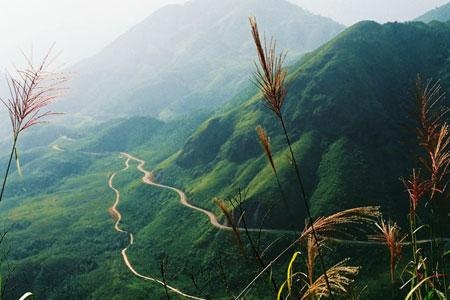
A part of the Hoang Lien Sa Pa National Park
2. Ba Be National Park
Ba Be National Park, located in Bac Kan Province, is the premier tourist site in northeast Viet Nam. The Park is named after Ba Be Lake, Vietnam's largest and highest, natural freshwater lake, situated at about 150 meters above sea level. The Lake is the centerpiece of a landscape dominated by Limestone Mountains and covered in thick forest.
Ba Be actually means 'three lakes' or 'Slam Pe' in the local Tay language. These lakes are Pe Leng, Pe Lu and Pe Lam. Ba Be is a continuous body of water with numerous small inlets and islets, stretching nearly 8 kilometers from north to south. Because of its rugged splendor, Ba Be is sometimes referred to as the "Ha Long Bay of the mountains". Ba Be was declared a national park in 1992 and covers 10,048 hectares. The National Park was established to conserve important ecosystems, rare plant and animal species and, in particular, the special landscapes centered on Ba Be Lake.

A part of the Ba Be National Park
3. Chu Mom Ray National Park
Chu Mom Ray National Park is situated in western Kon Tum province, in the Central Highlands, close to the point where Viet Nam, Cambodia and Lao PDR meet. Located in an area of medium high mountains, the Park is named after Chu Mom Ray, which is the highest (1,773 meters) mountain in the region.
Chu Mom Ray was established as a National Park in 2001. The Park covers a total land area of 56,621 hectares, comprising a strict protection area of 40,566 hectares, a forest rehabilitation area of 12,137 hectares and an administration and services area of 3,918 hectares.
The National Park is adjacent to Virachey National Park in the Stung Treng and Ratanikiri provinces of Cambodia and the Southeast Ghong Natural Reserve in the Attapeu province of Lao PDR. Chu Mom Ray is also an important forest watershed for the Ya ly-Se san-Plei Krong hydroelectric plant and Kon Tum province.
A part of the Chu Mom Ray National Park
4. Kon Ka Kinh National Park
Kon Ka Kinh was established as a National Park in 2002, with a total area of 41,780 hectares, and then declared an ASEAN Heritage Park in 2003. It is located in the north-eastern region of Gia Lai province within the administrative boundaries of Dak Roong, Kroong and Kon Pne communes (Kbang rural district), Ha Dong commune (Dac Doa rural district) and Ayun commune (Mang Yang rural district).
The Park straddles two catchments. Streams originating east of the Park feed the Ba River, which flows east, into the South China Sea, while west of the Park lies within the catchment of the Mekong River. Because of the steep topography, rivers and streams originating from the Park are often short, narrow and fast fl owing, with many waterfalls.
The Park has high, steep mountains in the northeast and flatter areas in the southwest. The highest point is the Kon Ka Kinh Mountain at 1,748 meters above sea level (asl) while the southwest area is below 700 meters asl.
Local people depend on the Park's resources for their firewood, honey and rattans. They also use at least 110 plant species with traditionally-known medicinal values. Use of plants in traditional medicine is widespread amongst local people, although the commercial potential of most of these species remains untapped.
A part of the Kon Ka Kinh National Park
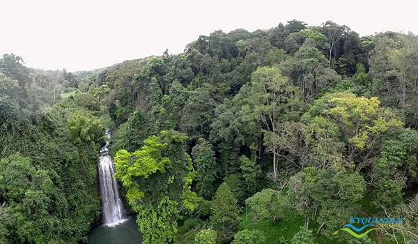
5. U Minh Thuong National Park
Located in An Minh and Vinh Thuan districts, Kien Giang Province about 365km south-west of Ho Chi Minh City, U Minh Thuong National Park (UMTNP) is a vast wetlands area rich in fish and waterbirds. The park lies 0.5 to 0.7 meters above sea level and covers a total area of 21,800 hectares. The park is divided into a core zone comprising 2,851 hectares and a buffer zone covering 13,291 hectares.
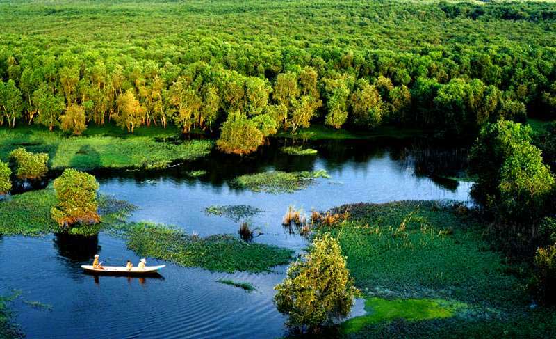
A part of the U Minh Thuong National Park
A new water management solution launched in 2010 has helped the park recover its mangrove forest system and biological diversity, which were damaged by a forest fire in 2002, according to Director of the park Pham Quoc Dan.
The park plans to zone off 550 hectares for forest regeneration and cultivate 350 more hectares of forests, and 4,000 indigenous trees on degrading peat land, as well as root out invasive exotic plants. It will also build a water irrigation system to maintain humidity for forests during the 2016 – 2017 dry seasons.
U Minh Thuong National Park was recognised as Viet Nam’s 8th Ramsar site in February 2016. The park is the 2,228th Ramsar site in the world. Ramsar, or the Convention of Wetlands, is an intergovernmental treaty that provides a framework for conservation and use of wetlands. Covering 21,107 hectares, the park is home to one of the most important submerged land areas in the Mekong Delta.
6. Bai Tu Long National Park
Bai Tu Long National Park (Vietnamese: Vườn quốc gia Bái Tử Long) is a protected area zone in northeastern Vietnam. It was established in 2001, succeeding from the former Ba Mun National Conservation Zone. It is one of seven Vietnamese amphibian national parks which has both terrestrial zone and aquatic zone.
It is located within Bai Tu Long Bay, which with Hạ Long Bay forms an impressive scenery of sea and islands. Including thousands of islands and rocks, they create one of the most beautiful bays in the world.
It fully satisfies the six criteria of an ASEAN Heritage Park, including ecological integrity, symbolism, natural features, high conservation value, management and preservation plan, and legality.
Over the past years, the conservation centre of Bai Tu Long National Park has salvaged, taken care of and released over 200 animal individuals and five sea turtles back into the wild on Ba Mun Island. It has also collaborated with many international organisations to implement a number of projects in the preservation of sea turtles, biodiversity management and preservation capacity building, and development of community-based ecotourism.
Bai Tu Long has become the sixth Vietnamese national park acknowledged as the ASEAN heritage park behind Ba Be, Hoang Lien, Kon Ka Kinh, Chu Mom Ray and U Minh Thuong.

A part of the Bai Tu Long National Park
Realizing the importance of biodiversity, the Vietnamese government has taken drastic actions in recent years to boost conservation work. So far, 43 cities and provinces across the country have built and implemented action programmes on biodiversity, while 16 have built and issued provincial-level biodiversity conservation plans. Vietnam has many significant preservation areas recognized by the international community, including eight Ramsar wetland sites, nine world biosphere reserves, two world heritage sites, six ASEAN Heritage Parks, and 63 critical bird areas globally announced by the BirdLife International.
Xuan Huong