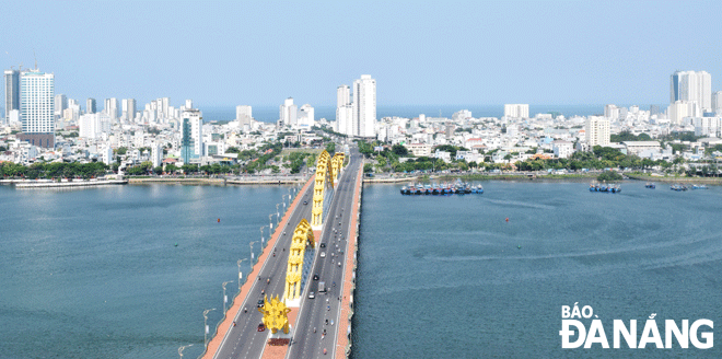
After 48 years since its liberation, especially from 1997 until now, Da Nang has experienced a rapid urban development pace. The city is aiming for 2050 to become a large, ecological, smart, sustainable city with unique identity.

Da Nang urban area has been developing strongly to the east. Photo: Hoang Hiep
Rapid urban development reaches high, reaches far
After 26 years from the day Da Nang became a centrally-run city (January 1, 1997), from a small urban space, only encapsulated within Hai Chau, Thanh Khe and a part of districts Son Tra and Ngu Hanh Son, corresponding to an area of about 5,600ha, Da Nang has developed 18,396ha of urban construction land and 8,191ha of civil land. Until now, Da Nang has about 2,600 roads that have been invested in building technical infrastructure and named.
From a ‘city without height’, Da Nang now has about 150 high-rise buildings, hotels with 15 floors or more, especially apartments and hotels with 50, 57 storeys, in which those located along the eastern bank of the Han River and the the city’s eastern part account for about two-thirds of the total number of high-rise buildings of 15 floors or more in the city, according to the National Urban Development Programme for the 2012 - 2020 period.
By 2021, the city's urbanisation rate reached 87.2%, 42.2% higher than the set target. The percentage of permanent and semi-permanent houses in the inner city hit 99.2%, 24.2% higher than the set target. The rate of domestic wastewater collected and treated was 83.5% whilst lighting rate of main street and residential area, residential area, village was100%...
Expanding urban space, aiming for special urban area
By 2030, Da Nang will have become an international, eco-urban, modern and smart, livable seaport city with the stature as the nucleus of the urban chain and the growth pole of the key economic zone of the Central Viet Nam- Central Highlands regions and reaching the Asian level.
Specifically, by 2030, the land area of the urban area will be 20,148 ha, the tourist area 4,718 ha, the commercial - service area 1,223 ha. The urbanisation rate will reach over 90%; the average residential floor area per capita in urban at least 32m2; the ratio of traffic land to urban construction land 18% by 2030 and 26% by 2050; the rate of public passenger transport by 2030 10-25%.
According to the head of the Board of Urban Affairs of the Da Nang Nanf People's Council Nguyen Thanh Tien, according to the urban development plan according to the Da Nang Master Plan towards 2030, Da Nang is confirmed to be a grade 1 urban area, at the same time striving to become a special city in the future.
In the immediate future, the city needs to focus on completing the missing criteria of a grade 1 urban area. Also in this draft planning, by 2025, Hoa Vang District will meet the criteria of a grade 4 urban area with a high urbanization rate of more than 85%, eligible to become a town.
12 subdivisions, 3 urban areas, 1 ecological zone
According to the Da Nang Master Plan draft for the 2021 - 2030 period, with a vision towards 2050, the urban space is oriented to be organised into 12 sub-divisions according to 3 typical urban areas (waterside, green core and hillside areas) and one eco-zone; forming two economic belts based on development links, namely the northern belt comprising hi-tech industries, seaports and logistics and the southern belt being the innovation and hi-tech agriculture.
The 6 inner urban districts will consider developing towards oriented for redevelopment according to the ‘compact city’ model, reducing the construction density of the existing central urban core area, improving the land use coefficient, developing more urban utilities integrated to the traffic system, forming modern-style architectural works.
Particularly, a central business district (CBD), the commercial and business center of a city, containing commercial space and offices, will be developed, offering a high living standards for local dwellers.
Existing urban areas with a lower population density than the core one will develop with a higher population and construction density in accordance with regulations, highlighting public green spaces in residential areas and a transport system integrated into the city-wide public transport network.
In the central area, it is oriented to build an underground space system at public works, high-rise buildings, key intersections, station areas, urban railway lines connecting with underground parking and traffic tunnels to form a complete, multi-purpose underground space.
Reporting by Hoang Hiep - Translating by A.Thu